25
views
0
recommends
+1 Recommend
1 collections
    0
    shares
      • Record: found
      • Abstract: found
      • Article: found
      Is Open Access

      Spatially explicit assessment of heat health risk by using multi-sensor remote sensing images and socioeconomic data in Yangtze River Delta, China

      research-article

      Read this article at

      Bookmark
          There is no author summary for this article yet. Authors can add summaries to their articles on ScienceOpen to make them more accessible to a non-specialist audience.

          Abstract

          Background

          The increase in the frequency and intensity of extreme heat events, which are potentially associated with climate change in the near future, highlights the importance of heat health risk assessment, a significant reference for heat-related death reduction and intervention. However, a spatiotemporal mismatch exists between gridded heat hazard and human exposure in risk assessment, which hinders the identification of high-risk areas at finer scales.

          Methods

          A human settlement index integrated by nighttime light images, enhanced vegetation index, and digital elevation model data was utilized to assess the human exposure at high spatial resolution. Heat hazard and vulnerability index were generated by land surface temperature and demographic and socioeconomic census data, respectively. Spatially explicit assessment of heat health risk and its driving factors was conducted in the Yangtze River Delta (YRD), east China at 250 m pixel level.

          Results

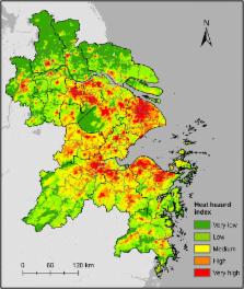
          High-risk areas were mainly distributed in the urbanized areas of YRD, which were mostly driven by high human exposure and heat hazard index. In some less-urbanized cities and suburban and rural areas of mega-cities, the heat health risks are in second priority. The risks in some less-developed areas were high despite the low human exposure index because of high heat hazard and vulnerability index.

          Conclusions

          This study illustrated a methodology for identifying high-risk areas by combining freely available multi-source data. Highly urbanized areas were considered hotspots of high heat health risks, which were largely driven by the increasing urban heat island effects and population density in urban areas. Repercussions of overheating were weakened due to the low social vulnerability in some central areas benefitting from the low proportion of sensitive population or the high level of socioeconomic development. By contrast, high social vulnerability intensifies heat health risks in some less-urbanized cities and suburban areas of mega-cities.

          Related collections

          Most cited references51

          • Record: found
          • Abstract: found
          • Article: found

          Heat stress and public health: a critical review.

          Heat is an environmental and occupational hazard. The prevention of deaths in the community caused by extreme high temperatures (heat waves) is now an issue of public health concern. The risk of heat-related mortality increases with natural aging, but persons with particular social and/or physical vulnerability are also at risk. Important differences in vulnerability exist between populations, depending on climate, culture, infrastructure (housing), and other factors. Public health measures include health promotion and heat wave warning systems, but the effectiveness of acute measures in response to heat waves has not yet been formally evaluated. Climate change will increase the frequency and the intensity of heat waves, and a range of measures, including improvements to housing, management of chronic diseases, and institutional care of the elderly and the vulnerable, will need to be developed to reduce health impacts.
            Bookmark
            • Record: found
            • Abstract: not found
            • Article: not found

            Synergistic Interactions between Urban Heat Islands and Heat Waves: The Impact in Cities Is Larger than the Sum of Its Parts*

              Bookmark
              • Record: found
              • Abstract: found
              • Article: found
              Is Open Access

              Mapping Community Determinants of Heat Vulnerability

              Background The evidence that heat waves can result in both increased deaths and illness is substantial, and concern over this issue is rising because of climate change. Adverse health impacts from heat waves can be avoided, and epidemiologic studies have identified specific population and community characteristics that mark vulnerability to heat waves. Objectives We situated vulnerability to heat in geographic space and identified potential areas for intervention and further research. Methods We mapped and analyzed 10 vulnerability factors for heat-related morbidity/mortality in the United States: six demographic characteristics and two household air conditioning variables from the U.S. Census Bureau, vegetation cover from satellite images, and diabetes prevalence from a national survey. We performed a factor analysis of these 10 variables and assigned values of increasing vulnerability for the four resulting factors to each of 39,794 census tracts. We added the four factor scores to obtain a cumulative heat vulnerability index value. Results Four factors explained > 75% of the total variance in the original 10 vulnerability variables: a) social/environmental vulnerability (combined education/poverty/race/green space), b) social isolation, c) air conditioning prevalence, and d) proportion elderly/diabetes. We found substantial spatial variability of heat vulnerability nationally, with generally higher vulnerability in the Northeast and Pacific Coast and the lowest in the Southeast. In urban areas, inner cities showed the highest vulnerability to heat. Conclusions These methods provide a template for making local and regional heat vulnerability maps. After validation using health outcome data, interventions can be targeted at the most vulnerable populations.
                Bookmark

                Author and article information

                Contributors
                ppcastle93@hotmail.com
                dingmingjun1128@163.com
                yangxuchao@zju.edu.cn
                kejiahu@zju.edu.cn
                qi@msu.edu
                Journal
                Int J Health Geogr
                Int J Health Geogr
                International Journal of Health Geographics
                BioMed Central (London )
                1476-072X
                25 May 2018
                25 May 2018
                2018
                : 17
                : 15
                Affiliations
                [1 ]ISNI 0000 0004 1759 700X, GRID grid.13402.34, Institute of Island and Coastal Ecosystems, Ocean College, , Zhejiang University, ; Zhoushan, 316021 China
                [2 ]ISNI 0000 0000 8732 9757, GRID grid.411862.8, Key Lab of Poyang Lake Wetland and Watershed Research of Ministry of Education, School of Geography and Environment, , Jiangxi Normal University, ; Nanchang, 330022 China
                [3 ]ISNI 0000 0001 2150 1785, GRID grid.17088.36, Center for Global Change and Earth Observations, , Michigan State University, ; East Lansing, MI 48823 USA
                Author information
                http://orcid.org/0000-0002-8130-7447
                Article
                135
                10.1186/s12942-018-0135-y
                5970500
                29801488
                bfc7828a-bd5e-48ba-b14e-0351226bb653
                © The Author(s) 2018

                Open AccessThis article is distributed under the terms of the Creative Commons Attribution 4.0 International License ( http://creativecommons.org/licenses/by/4.0/), which permits unrestricted use, distribution, and reproduction in any medium, provided you give appropriate credit to the original author(s) and the source, provide a link to the Creative Commons license, and indicate if changes were made. The Creative Commons Public Domain Dedication waiver ( http://creativecommons.org/publicdomain/zero/1.0/) applies to the data made available in this article, unless otherwise stated.

                History
                : 1 December 2017
                : 21 May 2018
                Funding
                Funded by: FundRef http://dx.doi.org/10.13039/501100001809, National Natural Science Foundation of China;
                Award ID: 41671035
                Award ID: 41371068
                Award Recipient :
                Categories
                Research
                Custom metadata
                © The Author(s) 2018

                Public health
                spatial risk assessment,heat health risk,remote sensing,gis,yangtze river delta
                Public health
                spatial risk assessment, heat health risk, remote sensing, gis, yangtze river delta

                Comments

                Comment on this article