1
views
0
recommends
+1 Recommend
1 collections
    0
    shares
      • Record: found
      • Abstract: found
      • Article: found
      Is Open Access

      Using image segmentation models to analyse high-resolution earth observation data: new tools to monitor disease risks in changing environments

      research-article

      Read this article at

      Bookmark
          There is no author summary for this article yet. Authors can add summaries to their articles on ScienceOpen to make them more accessible to a non-specialist audience.

          Abstract

          Background

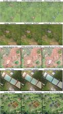
          In the near future, the incidence of mosquito-borne diseases may expand to new sites due to changes in temperature and rainfall patterns caused by climate change. Therefore, there is a need to use recent technological advances to improve vector surveillance methodologies. Unoccupied Aerial Vehicles (UAVs), often called drones, have been used to collect high-resolution imagery to map detailed information on mosquito habitats and direct control measures to specific areas. Supervised classification approaches have been largely used to automatically detect vector habitats. However, manual data labelling for model training limits their use for rapid responses. Open-source foundation models such as the Meta AI Segment Anything Model (SAM) can facilitate the manual digitalization of high-resolution images. This pre-trained model can assist in extracting features of interest in a diverse range of images. Here, we evaluated the performance of SAM through the Samgeo package, a Python-based wrapper for geospatial data, as it has not been applied to analyse remote sensing images for epidemiological studies.

          Results

          We tested the identification of two land cover classes of interest: water bodies and human settlements, using different UAV acquired imagery across five malaria-endemic areas in Africa, South America, and Southeast Asia. We employed manually placed point prompts and text prompts associated with specific classes of interest to guide the image segmentation and assessed the performance in the different geographic contexts. An average Dice coefficient value of 0.67 was obtained for buildings segmentation and 0.73 for water bodies using point prompts. Regarding the use of text prompts, the highest Dice coefficient value reached 0.72 for buildings and 0.70 for water bodies. Nevertheless, the performance was closely dependent on each object, landscape characteristics and selected words, resulting in varying performance.

          Conclusions

          Recent models such as SAM can potentially assist manual digitalization of imagery by vector control programs, quickly identifying key features when surveying an area of interest. However, accurate segmentation still requires user-provided manual prompts and corrections to obtain precise segmentation. Further evaluations are necessary, especially for applications in rural areas.

          Supplementary Information

          The online version contains supplementary material available at 10.1186/s12942-024-00371-w.

          Related collections

          Most cited references32

          • Record: found
          • Abstract: found
          • Article: not found

          Over half of known human pathogenic diseases can be aggravated by climate change

          It is relatively well accepted that climate change can affect human pathogenic diseases; however, the full extent of this risk remains poorly quantified. Here we carried out a systematic search for empirical examples about the impacts of ten climatic hazards sensitive to greenhouse gas (GHG) emissions on each known human pathogenic disease. We found that 58% (that is, 218 out of 375) of infectious diseases confronted by humanity worldwide have been at some point aggravated by climatic hazards; 16% were at times diminished. Empirical cases revealed 1,006 unique pathways in which climatic hazards, via different transmission types, led to pathogenic diseases. The human pathogenic diseases and transmission pathways aggravated by climatic hazards are too numerous for comprehensive societal adaptations, highlighting the urgent need to work at the source of the problem: reducing GHG emissions.
            Bookmark
            • Record: found
            • Abstract: found
            • Article: not found

            Endemic malaria in the Peruvian Amazon region of Iquitos.

            A cross-sectional study was conducted in the Peruvian Amazon to test the hypothesis that a reservoir of asymptomatic malaria parasitemic patients would form the basis for continuing malaria endemicity in the region. Active surveillance yielded a Plasmodium spp. slide-positive prevalence of 4.2% (43 of 1,023) and a polymerase chain reaction (PCR)-positive prevalence of 17.6% (144 of 819). Plasmodium vivax prevalence was 2.9% and 14.2% while Plasmodium falciparum prevalence was 1.3% and 2.6% by microscopy and PCR, respectively. Approximately two-thirds of slide-positive and one-fourth of PCR-positive people were symptomatic. Anemia was associated with slide positivity (P < 0.001) and PCR positivity for P. falciparum (P = 0.003). Sensitivity of field microscopy and agreement between field and reference laboratory microscopists were low, arguing for using PCR for epidemiologic investigation and malaria control. While these data confirm recent findings from the Brazilian Amazon suggesting that sufficient numbers of asymptomatic malaria parasitemic patients are present to form a persistent reservoir for continuous reinfection within the Peruvian Amazon region, these results also indicate that clinical immunity in human populations can be driven in malaria-endemic regions that do not have high intensity malaria transmission.
              Bookmark
              • Record: found
              • Abstract: found
              • Article: not found

              Mapping infectious disease landscapes: unmanned aerial vehicles and epidemiology.

              The potential applications of unmanned aerial vehicles (UAVs), or drones, have generated intense interest across many fields. UAVs offer the potential to collect detailed spatial information in real time at relatively low cost and are being used increasingly in conservation and ecological research. Within infectious disease epidemiology and public health research, UAVs can provide spatially and temporally accurate data critical to understanding the linkages between disease transmission and environmental factors. Using UAVs avoids many of the limitations associated with satellite data (e.g., long repeat times, cloud contamination, low spatial resolution). However, the practicalities of using UAVs for field research limit their use to specific applications and settings. UAVs fill a niche but do not replace existing remote-sensing methods.
                Bookmark

                Author and article information

                Contributors
                Fedra.Trujillano@glasgow.ac.uk
                Journal
                Int J Health Geogr
                Int J Health Geogr
                International Journal of Health Geographics
                BioMed Central (London )
                1476-072X
                19 May 2024
                19 May 2024
                2024
                : 23
                : 13
                Affiliations
                [1 ]School of Biodiversity, One Health & Veterinary Medicine, University of Glasgow, ( https://ror.org/00vtgdb53) Glasgow, Scotland UK
                [2 ]School of Geographical & Earth Sciences, University of Glasgow, ( https://ror.org/00vtgdb53) Glasgow, Scotland UK
                [3 ]Sorbonne Université, Institute du Cerveau - ICM, CNRS, Inria, AP-HP, Paris, Inserm France
                [4 ]Environmental Health and Ecological Sciences Department, Ifakara Health Institute, ( https://ror.org/04js17g72) P. O. Box 53, Ifakara, Tanzania
                [5 ]Centre National de Recherche et de Formation sur le Paludisme, ( https://ror.org/03y3jby41) Ouagadougou, Burkina Faso
                [6 ]Health Innovation Laboratory, Institute of Tropical Medicine “Alexander von Humboldt”, Universidad Peruana Cayetano Heredia, ( https://ror.org/03yczjf25) Lima, Peru
                [7 ]Saw Swee Hock School of Public Health, National University of Singapore and National University Health System, ( https://ror.org/01tgyzw49) Singapore, Singapore
                Article
                371
                10.1186/s12942-024-00371-w
                11102859
                38764024
                af30ce27-b734-44f5-8961-2f4338ca17ba
                © The Author(s) 2024

                Open Access This article is licensed under a Creative Commons Attribution 4.0 International License, which permits use, sharing, adaptation, distribution and reproduction in any medium or format, as long as you give appropriate credit to the original author(s) and the source, provide a link to the Creative Commons licence, and indicate if changes were made. The images or other third party material in this article are included in the article’s Creative Commons licence, unless indicated otherwise in a credit line to the material. If material is not included in the article’s Creative Commons licence and your intended use is not permitted by statutory regulation or exceeds the permitted use, you will need to obtain permission directly from the copyright holder. To view a copy of this licence, visit http://creativecommons.org/licenses/by/4.0/. The Creative Commons Public Domain Dedication waiver ( http://creativecommons.org/publicdomain/zero/1.0/) applies to the data made available in this article, unless otherwise stated in a credit line to the data.

                History
                : 29 February 2024
                : 29 April 2024
                Funding
                Funded by: BBSRC and EPSRC Impact Accelerator Accounts
                Award ID: BB/X511110/1
                Award ID: BB/X511110/1
                Award ID: BB/X511110/1
                Funded by: Wellcome Trust and Royal Society
                Award ID: 221963/Z/20/Z
                Categories
                Methodology
                Custom metadata
                © BioMed Central Ltd., part of Springer Nature 2024

                Public health
                segment anything model,mosquito-borne diseases,uav,drone,remote sensing.
                Public health
                segment anything model, mosquito-borne diseases, uav, drone, remote sensing.

                Comments

                Comment on this article