61
views
0
recommends
+1 Recommend
0 collections
    0
    shares
      • Record: found
      • Abstract: found
      • Article: found
      Is Open Access

      Passive Sensor Integration for Vehicle Self-Localization in Urban Traffic Environment †

      research-article

      Read this article at

      Bookmark
          There is no author summary for this article yet. Authors can add summaries to their articles on ScienceOpen to make them more accessible to a non-specialist audience.

          Abstract

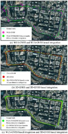
          This research proposes an accurate vehicular positioning system which can achieve lane-level performance in urban canyons. Multiple passive sensors, which include Global Navigation Satellite System (GNSS) receivers, onboard cameras and inertial sensors, are integrated in the proposed system. As the main source for the localization, the GNSS technique suffers from Non-Line-Of-Sight (NLOS) propagation and multipath effects in urban canyons. This paper proposes to employ a novel GNSS positioning technique in the integration. The employed GNSS technique reduces the multipath and NLOS effects by using the 3D building map. In addition, the inertial sensor can describe the vehicle motion, but has a drift problem as time increases. This paper develops vision-based lane detection, which is firstly used for controlling the drift of the inertial sensor. Moreover, the lane keeping and changing behaviors are extracted from the lane detection function, and further reduce the lateral positioning error in the proposed localization system. We evaluate the integrated localization system in the challenging city urban scenario. The experiments demonstrate the proposed method has sub-meter accuracy with respect to mean positioning error.

          Related collections

          Most cited references70

          • Record: found
          • Abstract: found
          • Article: not found

          GOLD: a parallel real-time stereo vision system for generic obstacle and lane detection.

          This paper describes the generic obstacle and lane detection system (GOLD), a stereo vision-based hardware and software architecture to be used on moving vehicles to increment road safety. Based on a full-custom massively parallel hardware, it allows to detect both generic obstacles (without constraints on symmetry or shape) and the lane position in a structured environment (with painted lane markings) at a rate of 10 Hz. Thanks to a geometrical transform supported by a specific hardware module, the perspective effect is removed from both left and right stereo images; the left is used to detect lane markings with a series of morphological filters, while both remapped stereo images are used for the detection of free-space in front of the vehicle. The output of the processing is displayed on both an on-board monitor and a control-panel to give visual feedbacks to the driver. The system was tested on the mobile laboratory (MOB-LAB) experimental land vehicle, which was driven for more than 3000 km along extra-urban roads and freeways at speeds up to 80 km/h, and demonstrated its robustness with respect to shadows and changing illumination conditions, different road textures, and vehicle movement.
            Bookmark
            • Record: found
            • Abstract: not found
            • Article: not found

            Performance Enhancement of MEMS-Based INS/GPS Integration for Low-Cost Navigation Applications

              Bookmark
              • Record: found
              • Abstract: not found
              • Article: not found

              GPS Multipath Mitigation for Urban Area Using Omnidirectional Infrared Camera

                Bookmark

                Author and article information

                Contributors
                Role: Academic Editor
                Journal
                Sensors (Basel)
                Sensors (Basel)
                sensors
                Sensors (Basel, Switzerland)
                MDPI
                1424-8220
                03 December 2015
                December 2015
                : 15
                : 12
                : 30199-30220
                Affiliations
                Institute of Industrial Science, The University of Tokyo, 4-6-1 Komaba, Meguro-ku, Tokyo 153-8505, Japan; qmohsu@ 123456kmj.iis.u-tokyo.ac.jp (L.-T.H.); kamijo@ 123456iis.u-tokyo.ac.jp (S.K.)
                Author notes
                [* ]Correspondence: guyanlei@ 123456kmj.iis.u-tokyo.ac.jp ; Tel.: +81-354-526-273 (ext. 56273); Fax: +81-354-526-274
                [†]

                This paper is an extended version of the paper entitled “GNSS/INS/on-board camera integration for vehicle self-localization in urban canyon”, presented at IEEE 18th International Conference on Intelligent Transportation Systems, Gran Canaria, Spain, 15–18 September 2015.

                Article
                sensors-15-29795
                10.3390/s151229795
                4721716
                26633420
                8a3fea60-5fd0-4093-8b2f-6e6b0eeea6aa
                © 2015 by the authors; licensee MDPI, Basel, Switzerland.

                This article is an open access article distributed under the terms and conditions of the Creative Commons by Attribution (CC-BY) license ( http://creativecommons.org/licenses/by/4.0/).

                History
                : 12 October 2015
                : 26 November 2015
                Categories
                Article

                Biomedical engineering
                vehicle self-localization,sensor integration,3d map,gnss,inertial sensor,vision,lane detection,particle filter

                Comments

                Comment on this article