118
views
0
recommends
+1 Recommend
0 collections
    0
    shares
      • Record: found
      • Abstract: found
      • Article: found
      Is Open Access

      Analyzing the spatio-temporal relationship between dengue vector larval density and land-use using factor analysis and spatial ring mapping

      research-article

      Read this article at

      Bookmark
          There is no author summary for this article yet. Authors can add summaries to their articles on ScienceOpen to make them more accessible to a non-specialist audience.

          Abstract

          Background

          Dengue, a mosquito-borne febrile viral disease, is found in tropical and sub-tropical regions and is now extending its range to temperate regions. The spread of the dengue viruses mainly depends on vector population ( Aedes aegypti and Aedes albopictus), which is influenced by changing climatic conditions and various land-use/land-cover types. Spatial display of the relationship between dengue vector density and land-cover types is required to describe a near-future viral outbreak scenario. This study is aimed at exploring how land-cover types are linked to the behavior of dengue-transmitting mosquitoes.

          Methods

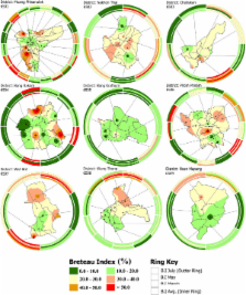
          Surveys were conducted in 92 villages of Phitsanulok Province Thailand. The sampling was conducted on three separate occasions in the months of March, May and July. Dengue indices, i.e. container index (C.I.), house index (H.I.) and Breteau index (B.I.) were used to map habitats conducible to dengue vector growth. Spatial epidemiological analysis using Bivariate Pearson’s correlation was conducted to evaluate the level of interdependence between larval density and land-use types. Factor analysis using principal component analysis (PCA) with varimax rotation was performed to ascertain the variance among land-use types. Furthermore, spatial ring method was used as to visualize spatially referenced, multivariate and temporal data in single information graphic.

          Results

          Results of dengue indices showed that the settlements around gasoline stations/workshops, in the vicinity of marsh/swamp and rice paddy appeared to be favorable habitat for dengue vector propagation at highly significant and positive correlation (p = 0.001) in the month of May. Settlements around the institutional areas were highly significant and positively correlated (p = 0.01) with H.I. in the month of March. Moreover, dengue indices in the month of March showed a significant and positive correlation (p <= 0.05) with deciduous forest. The H.I. of people living around horticulture land were significantly and positively correlated (p = 0.05) during the month of May, and perennial vegetation showed a highly significant and positive correlation (p = 0.001) in the month of March with C.I. and significant and positive correlation (p <= 0.05) with B.I., respectively.

          Conclusions

          The study concluded that gasoline stations/workshops, rice paddy, marsh/swamp and deciduous forests played highly significant role in dengue vector growth. Thus, the spatio-temporal relationships of dengue vector larval density and land-use types may help to predict favorable dengue habitat, and thereby enables public healthcare managers to take precautionary measures to prevent impending dengue outbreak.

          Related collections

          Most cited references34

          • Record: found
          • Abstract: not found
          • Article: not found

          Estimating historical changes in global land cover: Croplands from 1700 to 1992

            Bookmark
            • Record: found
            • Abstract: not found
            • Article: not found

            GRAZING SYSTEMS, ECOSYSTEM RESPONSES, AND GLOBAL CHANGE

              Bookmark
              • Record: found
              • Abstract: found
              • Article: not found

              Spatial epidemiology: an emerging (or re-emerging) discipline.

              Spatial epidemiology is the study of spatial variation in disease risk or incidence. Several ecological processes can result in strong spatial patterns of such risk or incidence: for example, pathogen dispersal might be highly localized, vectors or reservoirs for pathogens might be spatially restricted, or susceptible hosts might be clumped. Here, we briefly describe approaches to spatial epidemiology that are spatially implicit, such as metapopulation models of disease transmission, and then focus on research in spatial epidemiology that is spatially explicit, such as the creation of risk maps for particular geographical areas. Although the spatial dynamics of infectious diseases are the subject of intensive study, the impacts of landscape structure on epidemiological processes have so far been neglected. The few studies that demonstrate how landscape composition (types of elements) and configuration (spatial positions of those elements) influence disease risk or incidence suggest that a true integration of landscape ecology with epidemiology will be fruitful.
                Bookmark

                Author and article information

                Contributors
                Journal
                BMC Public Health
                BMC Public Health
                BMC Public Health
                BioMed Central
                1471-2458
                2012
                9 October 2012
                : 12
                : 853
                Affiliations
                [1 ]Remote Sensing and GIS, School of Engineering and Technology, Asian Institute of Technology (AIT), P.O. Box 4, Pathumthani 12120, Klong Luang, Thailand
                [2 ]The Office of Disease Prevention and Control, Bureau of Vector Borne Disease (9th), Ministry of Public Health, Wat bot road, Muang Phitsanulok 65000, Thailand
                [3 ], Institut de Recherche pour le Développement (IRD), UMR 190, Marseille, France
                Article
                1471-2458-12-853
                10.1186/1471-2458-12-853
                3598814
                23043443
                712c6d19-3e73-4137-8c01-c30940b76a47
                Copyright ©2012 Sarfraz et al; licensee BioMed Central Ltd.

                This is an Open Access article distributed under the terms of the Creative Commons Attribution License ( http://creativecommons.org/licenses/by/2.0), which permits unrestricted use, distribution, and reproduction in any medium, provided the original work is properly cited.

                History
                : 19 April 2012
                : 3 October 2012
                Categories
                Research Article

                Public health
                Public health

                Comments

                Comment on this article