3
views
0
recommends
+1 Recommend
0 collections
    0
    shares
      • Record: found
      • Abstract: found
      • Article: found
      Is Open Access

      Bird Satellite Tracking Revealed Critical Protection Gaps in East Asian–Australasian Flyway

      research-article

      Read this article at

      Bookmark
          There is no author summary for this article yet. Authors can add summaries to their articles on ScienceOpen to make them more accessible to a non-specialist audience.

          Abstract

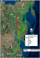
          Most migratory birds depend on stopover sites, which are essential for refueling during migration and affect their population dynamics. In the East Asian–Australasian Flyway (EAAF), however, the stopover ecology of migratory waterfowl is severely under-studied. The knowledge gaps regarding the timing, intensity and duration of stopover site usages prevent the development of effective and full annual cycle conservation strategies for migratory waterfowl in EAAF. In this study, we obtained a total of 33,493 relocations and visualized 33 completed spring migratory paths of five geese species using satellite tracking devices. We delineated 2,192,823 ha as the key stopover sites along the migration routes and found that croplands were the largest land use type within the stopover sites, followed by wetlands and natural grasslands (62.94%, 17.86% and 15.48% respectively). We further identified the conservation gaps by overlapping the stopover sites with the World Database on Protected Areas (PA). The results showed that only 15.63% (or 342,757 ha) of the stopover sites are covered by the current PA network. Our findings fulfil some key knowledge gaps for the conservation of the migratory waterbirds along the EAAF, thus enabling an integrative conservation strategy for migratory water birds in the flyway.

          Related collections

          Most cited references62

          • Record: found
          • Abstract: not found
          • Article: not found

          Links between worlds: unraveling migratory connectivity

            Bookmark
            • Record: found
            • Abstract: found
            • Article: not found

            Analyzing animal movements using Brownian bridges.

            By studying animal movements, researchers can gain insight into many of the ecological characteristics and processes important for understanding population-level dynamics. We developed a Brownian bridge movement model (BBMM) for estimating the expected movement path of an animal, using discrete location data obtained at relatively short time intervals. The BBMM is based on the properties of a conditional random walk between successive pairs of locations, dependent on the time between locations, the distance between locations, and the Brownian motion variance that is related to the animal's mobility. We describe two critical developments that enable widespread use of the BBMM, including a derivation of the model when location data are measured with error and a maximum likelihood approach for estimating the Brownian motion variance. After the BBMM is fitted to location data, an estimate of the animal's probability of occurrence can be generated for an area during the time of observation. To illustrate potential applications, we provide three examples: estimating animal home ranges, estimating animal migration routes, and evaluating the influence of fine-scale resource selection on animal movement patterns.
              Bookmark
              • Record: found
              • Abstract: found
              • Article: not found

              Migratory animals couple biodiversity and ecosystem functioning worldwide.

              Animal migrations span the globe, involving immense numbers of individuals from a wide range of taxa. Migrants transport nutrients, energy, and other organisms as they forage and are preyed upon throughout their journeys. These highly predictable, pulsed movements across large spatial scales render migration a potentially powerful yet underappreciated dimension of biodiversity that is intimately embedded within resident communities. We review examples from across the animal kingdom to distill fundamental processes by which migratory animals influence communities and ecosystems, demonstrating that they can uniquely alter energy flow, food-web topology and stability, trophic cascades, and the structure of metacommunities. Given the potential for migration to alter ecological networks worldwide, we suggest an integrative framework through which community dynamics and ecosystem functioning may explicitly consider animal migrations.
                Bookmark

                Author and article information

                Journal
                Int J Environ Res Public Health
                Int J Environ Res Public Health
                ijerph
                International Journal of Environmental Research and Public Health
                MDPI
                1661-7827
                1660-4601
                30 March 2019
                April 2019
                : 16
                : 7
                : 1147
                Affiliations
                [1 ]School of Nature Conservation, Beijing Forestry University, Beijing 100083, China; leijialinbjfu@ 123456foxmail.com (J.L.); jiayifei@ 123456bjfu.edu.cn (Y.J.); holidayzuo@ 123456126.com (A.Z.); zengqing@ 123456bjfu.edu.cn (Q.Z.); linlu.shi@ 123456foxmail.com (L.S.); lucai.wetland@ 123456foxmail.com (C.L.)
                [2 ]Co-Innovation Center for Sustainable Forestry in Southern China, College of Biology and the Environment, Nanjing Forestry University, Jiangsu 210037, China; zhouyan.eco@ 123456foxmail.com
                [3 ]East Dongting Lake National Nature Reserve Authority, Yueyang, Hunan 414000, China; zhanghong258@ 123456sina.com
                [4 ]Science Division, Office of Environment and Heritage, Sydney, NSW 2141, Australia
                Author notes
                Author information
                https://orcid.org/0000-0003-1774-7402
                https://orcid.org/0000-0003-3783-3826
                Article
                ijerph-16-01147
                10.3390/ijerph16071147
                6479383
                30935053
                6fb030ab-daea-41f6-8ca6-fc1165e1f329
                © 2019 by the authors.

                Licensee MDPI, Basel, Switzerland. This article is an open access article distributed under the terms and conditions of the Creative Commons Attribution (CC BY) license ( http://creativecommons.org/licenses/by/4.0/).

                History
                : 21 January 2019
                : 27 March 2019
                Categories
                Article

                Public health
                migration route,stopover,utilization distribution,croplands,northeast china plains,bohai bay

                Comments

                Comment on this article