7
views
0
recommends
+1 Recommend
1 collections
    0
    shares
      • Record: found
      • Abstract: found
      • Article: found
      Is Open Access

      Revealing the widespread potential of forests to increase low level cloud cover

      research-article

      Read this article at

      Bookmark
          There is no author summary for this article yet. Authors can add summaries to their articles on ScienceOpen to make them more accessible to a non-specialist audience.

          Abstract

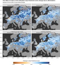
          Forests play a key role in humanity’s current challenge to mitigate climate change thanks to their capacity to sequester carbon. Preserving and expanding forest cover is considered essential to enhance this carbon sink. However, changing the forest cover can further affect the climate system through biophysical effects. One such effect that is seldom studied is how afforestation can alter the cloud regime, which can potentially have repercussions on the hydrological cycle, the surface radiation budget and on planetary albedo itself. Here we provide a global scale assessment of this effect derived from satellite remote sensing observations. We show that for 67% of sampled areas across the world, afforestation would increase low level cloud cover, which should have a cooling effect on the planet. We further reveal a dependency of this effect on forest type, notably in Europe where needleleaf forests generate more clouds than broadleaf forests.

          Abstract

          Forests can influence climate by affecting low cloud formation, but where and when this occurs is not well known. Here, the authors provide a global-scale assessment, based on satellite remote sensing observations, suggesting afforestation mostly increases low cloud cover which could potentially cool surface temperatures.

          Related collections

          Most cited references73

          • Record: found
          • Abstract: not found
          • Article: not found

          Google Earth Engine: Planetary-scale geospatial analysis for everyone

            Bookmark
            • Record: found
            • Abstract: found
            • Article: not found

            High-resolution global maps of 21st-century forest cover change.

            Quantification of global forest change has been lacking despite the recognized importance of forest ecosystem services. In this study, Earth observation satellite data were used to map global forest loss (2.3 million square kilometers) and gain (0.8 million square kilometers) from 2000 to 2012 at a spatial resolution of 30 meters. The tropics were the only climate domain to exhibit a trend, with forest loss increasing by 2101 square kilometers per year. Brazil's well-documented reduction in deforestation was offset by increasing forest loss in Indonesia, Malaysia, Paraguay, Bolivia, Zambia, Angola, and elsewhere. Intensive forestry practiced within subtropical forests resulted in the highest rates of forest change globally. Boreal forest loss due largely to fire and forestry was second to that in the tropics in absolute and proportional terms. These results depict a globally consistent and locally relevant record of forest change.
              Bookmark
              • Record: found
              • Abstract: found
              • Article: not found

              High-resolution mapping of global surface water and its long-term changes.

              The location and persistence of surface water (inland and coastal) is both affected by climate and human activity and affects climate, biological diversity and human wellbeing. Global data sets documenting surface water location and seasonality have been produced from inventories and national descriptions, statistical extrapolation of regional data and satellite imagery, but measuring long-term changes at high resolution remains a challenge. Here, using three million Landsat satellite images, we quantify changes in global surface water over the past 32 years at 30-metre resolution. We record the months and years when water was present, where occurrence changed and what form changes took in terms of seasonality and persistence. Between 1984 and 2015 permanent surface water has disappeared from an area of almost 90,000 square kilometres, roughly equivalent to that of Lake Superior, though new permanent bodies of surface water covering 184,000 square kilometres have formed elsewhere. All continental regions show a net increase in permanent water, except Oceania, which has a fractional (one per cent) net loss. Much of the increase is from reservoir filling, although climate change is also implicated. Loss is more geographically concentrated than gain. Over 70 per cent of global net permanent water loss occurred in the Middle East and Central Asia, linked to drought and human actions including river diversion or damming and unregulated withdrawal. Losses in Australia and the USA linked to long-term droughts are also evident. This globally consistent, validated data set shows that impacts of climate change and climate oscillations on surface water occurrence can be measured and that evidence can be gathered to show how surface water is altered by human activities. We anticipate that this freely available data will improve the modelling of surface forcing, provide evidence of state and change in wetland ecotones (the transition areas between biomes), and inform water-management decision-making.
                Bookmark

                Author and article information

                Contributors
                gduveiller@bgc-jena.mpg.de
                alessandro.cescatti@ec.europa.eu
                Journal
                Nat Commun
                Nat Commun
                Nature Communications
                Nature Publishing Group UK (London )
                2041-1723
                15 July 2021
                15 July 2021
                2021
                : 12
                : 4337
                Affiliations
                [1 ]GRID grid.434554.7, ISNI 0000 0004 1758 4137, European Commission Joint Research Centre, ; Ispra (VA), Italy
                [2 ]GRID grid.425296.e, ISNI 0000 0001 2198 2419, Remote Sensing Centre, , Institute of Geodesy and Cartography, ; Warsaw, Poland
                [3 ]GRID grid.419500.9, ISNI 0000 0004 0491 7318, Present Address: Max Planck Institute for Biogeochemistry, ; Jena, Germany
                [4 ]GRID grid.423782.8, ISNI 0000 0001 2205 5473, Present Address: Institute for Environmental Protection and Research (ISPRA), ; Roma, Italy
                Author information
                http://orcid.org/0000-0002-6471-8404
                http://orcid.org/0000-0002-1419-3734
                http://orcid.org/0000-0002-8185-2074
                http://orcid.org/0000-0001-8460-4183
                http://orcid.org/0000-0001-9864-2084
                Article
                24551
                10.1038/s41467-021-24551-5
                8282670
                34267204
                d1f8082f-1876-47ec-b651-bc847ad98bc1
                © The Author(s) 2021

                Open Access This article is licensed under a Creative Commons Attribution 4.0 International License, which permits use, sharing, adaptation, distribution and reproduction in any medium or format, as long as you give appropriate credit to the original author(s) and the source, provide a link to the Creative Commons license, and indicate if changes were made. The images or other third party material in this article are included in the article’s Creative Commons license, unless indicated otherwise in a credit line to the material. If material is not included in the article’s Creative Commons license and your intended use is not permitted by statutory regulation or exceeds the permitted use, you will need to obtain permission directly from the copyright holder. To view a copy of this license, visit http://creativecommons.org/licenses/by/4.0/.

                History
                : 15 September 2020
                : 18 June 2021
                Funding
                Funded by: FundRef https://doi.org/10.13039/501100000780, European Commission (EC);
                Categories
                Article
                Custom metadata
                © The Author(s) 2021

                Uncategorized
                ecosystem services,climate-change mitigation,forestry
                Uncategorized
                ecosystem services, climate-change mitigation, forestry

                Comments

                Comment on this article