- Record: found
- Abstract: found
- Article: found
Spatial pattern evolution and prediction scenario of habitat quality in typical fragile ecological region, China: A case study of the Yellow River floodplain area
Read this article at
Abstract
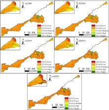
The Yellow River basin is an important area for China to implement ecological protection policies. Studying the habitat quality of the Yellow River floodplain area is of great significance to the ecological security and sustainable development of the entire basin. This study primarily investigated the spatial pattern of habitat quality in the Yellow River floodplain area from 2000 to 2020, then, we also simulated changes of habitat quality in 2025–2035 and analyzed the influencing factors by coupling the PLUS (Patch-generating Land Use Simulation) model, InVEST (Integrated Valuation of Ecosystem Services and Trade-offs) model and RF (Random Forest) model. The results showed that:(1) From 2000 to 2020, cultivated land and build-up land constituted an important part of the Yellow River floodplain area, and the growth rate of build-up land was fast. (2) We also found that the ecological land (forest land, grassland, waterbody) had a higher contribution value to the habitat quality, while the build-up land had a lower contribution value to the habitat quality. (3) Overall, the habitat quality of the floodplain area showed a degradation trend from 2000 to 2020. In addition, the regions with low habitat quality accounted for the major proportion. (4) Based on the calculation results of the Random Forest (RF) model, we found that topographical relief (TR) and land use intensity (LUI) were the two most important factors affecting habitat quality of the floodplain area. (5) According to the four scenarios from 2025 to 2035, it is found that the habitat quality level would be the highest under the ecological protection scenario, while under the urban development scenario its level would be the lowest. This study attempts to combine the RF model with PLUS model to improve the objectivity and accuracy of the future prediction scenario of habitat quality, which can provide scientific reference for ecological governance and policy formulation in the Yellow River floodplain area.
Highlights
-
•
The habitat quality of the Yellow River floodplain area showed a degradation trend from 2000 to 2020.
-
•
Coupling RF model, PLUS model and InVEST model to improve the accuracy of future prediction scenario of habitat quality.
-
•
The habitat quality levels would be significant differences under the four prediction scenarios from 2025 to 2035.
Related collections
Most cited references55
- Record: found
- Abstract: not found
- Article: not found
Understanding the drivers of sustainable land expansion using a patch-generating land use simulation (PLUS) model: A case study in Wuhan, China
- Record: found
- Abstract: not found
- Article: not found