1
views
0
recommends
+1 Recommend
0 collections
    0
    shares
      • Record: found
      • Abstract: found
      • Article: found
      Is Open Access

      Surface ruptures and off-fault deformation of the October 2016 central Italy earthquakes from DInSAR data

      research-article

      Read this article at
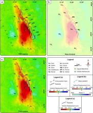
      Bookmark
          There is no author summary for this article yet. Authors can add summaries to their articles on ScienceOpen to make them more accessible to a non-specialist audience.

          Abstract

          Large magnitude earthquakes produce complex surface deformations, which are typically mapped by field geologists within the months following the mainshock. We present detailed maps of the surface deformation pattern produced by the M. Vettore Fault System during the October 2016 earthquakes in central Italy, derived from ALOS-2 SAR data, via DInSAR technique. On these maps, we trace a set of cross-sections to analyse the coseismic vertical displacement, essential to identify both surface fault ruptures and off-fault deformations. At a local scale, we identify a large number of surface ruptures, in agreement with those observed in the field. At a larger scale, the inferred coseismic deformation shows a typical long-wavelength convex curvature of the subsiding block, not directly recognizable in the field. The detection of deformation patterns from DInSAR technique can furnish important constraints on the activated fault segments, their spatial distribution and interaction soon after the seismic events. Thanks to the large availability of satellite SAR acquisitions, the proposed methodological approach can be potentially applied to worldwide earthquakes (according to the environmental characteristics of the sensed scene) to provide a wider and faster picture of surface ruptures. Thus, the derived information can be crucial for emergency management by civil protection and helpful to drive and support the geological field surveys during an ongoing seismic crisis.

          Related collections

          Most cited references37

          • Record: found
          • Abstract: not found
          • Article: not found

          The 2016 Central Italy Seismic Sequence: A First Look at the Mainshocks, Aftershocks, and Source Models

            Bookmark
            • Record: found
            • Abstract: not found
            • Article: not found

            Radar interferometry and its application to changes in the Earth's surface

              Bookmark
              • Record: found
              • Abstract: not found
              • Article: not found

              The displacement field of the Landers earthquake mapped by radar interferometry

                Bookmark

                Author and article information

                Contributors
                massimiliano.porreca@unipg.it
                Journal
                Sci Rep
                Sci Rep
                Scientific Reports
                Nature Publishing Group UK (London )
                2045-2322
                24 February 2022
                24 February 2022
                2022
                : 12
                : 3172
                Affiliations
                [1 ]GRID grid.9027.c, ISNI 0000 0004 1757 3630, Dipartimento di Fisica e Geologia, Centro InteRUniversitario per l’analisi Sismotettonica Tridimensionale (CRUST), , Università degli studi di Perugia, ; 06123 Perugia, Italy
                [2 ]GRID grid.473657.4, ISNI 0000 0000 8518 0610, Istituto per il Rilevamento Elettromagnetico dell’Ambiente, IREA-CNR, ; Naples, Italy
                Article
                7068
                10.1038/s41598-022-07068-9
                8873333
                35210512
                1dd2a5fc-79d0-42e8-ac5f-577cd3b13a88
                © The Author(s) 2022

                Open Access This article is licensed under a Creative Commons Attribution 4.0 International License, which permits use, sharing, adaptation, distribution and reproduction in any medium or format, as long as you give appropriate credit to the original author(s) and the source, provide a link to the Creative Commons licence, and indicate if changes were made. The images or other third party material in this article are included in the article's Creative Commons licence, unless indicated otherwise in a credit line to the material. If material is not included in the article's Creative Commons licence and your intended use is not permitted by statutory regulation or exceeds the permitted use, you will need to obtain permission directly from the copyright holder. To view a copy of this licence, visit http://creativecommons.org/licenses/by/4.0/.

                History
                : 23 July 2021
                : 4 February 2022
                Funding
                Funded by: FundRef http://dx.doi.org/10.13039/501100003407, Ministero dell’Istruzione, dell’Università e della Ricerca;
                Award ID: PRIN2017BARCH
                Award ID: PRIN2017BARCH
                Award Recipient :
                Funded by: H2020 EPOS-SP
                Award ID: GA 871121
                Award Recipient :
                Funded by: ENVRI-FAIR
                Award ID: GA 824068
                Award Recipient :
                Categories
                Article
                Custom metadata
                © The Author(s) 2022

                Uncategorized
                natural hazards,structural geology,geophysics,seismology,tectonics
                Uncategorized
                natural hazards, structural geology, geophysics, seismology, tectonics

                Comments

                Comment on this article