13
views
0
recommends
+1 Recommend
0 collections
    0
    shares
      • Record: found
      • Abstract: found
      • Article: found
      Is Open Access

      A Novel Grid SINS/DVL Integrated Navigation Algorithm for Marine Application

      research-article

      Read this article at

      Bookmark
          There is no author summary for this article yet. Authors can add summaries to their articles on ScienceOpen to make them more accessible to a non-specialist audience.

          Abstract

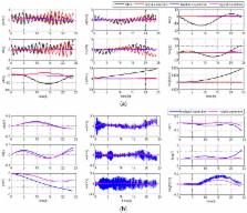
          Integrated navigation algorithms under the grid frame have been proposed based on the Kalman filter (KF) to solve the problem of navigation in some special regions. However, in the existing study of grid strapdown inertial navigation system (SINS)/Doppler velocity log (DVL) integrated navigation algorithms, the Earth models of the filter dynamic model and the SINS mechanization are not unified. Besides, traditional integrated systems with the KF based correction scheme are susceptible to measurement errors, which would decrease the accuracy and robustness of the system. In this paper, an adaptive robust Kalman filter (ARKF) based hybrid-correction grid SINS/DVL integrated navigation algorithm is designed with the unified reference ellipsoid Earth model to improve the navigation accuracy in middle-high latitude regions for marine application. Firstly, to unify the Earth models, the mechanization of grid SINS is introduced and the error equations are derived based on the same reference ellipsoid Earth model. Then, a more accurate grid SINS/DVL filter model is designed according to the new error equations. Finally, a hybrid-correction scheme based on the ARKF is proposed to resist the effect of measurement errors. Simulation and experiment results show that, compared with the traditional algorithms, the proposed navigation algorithm can effectively improve the navigation performance in middle-high latitude regions by the unified Earth models and the ARKF based hybrid-correction scheme.

          Related collections

          Most cited references29

          • Record: found
          • Abstract: not found
          • Article: not found

          AUV Navigation and Localization: A Review

            Bookmark
            • Record: found
            • Abstract: not found
            • Article: not found

            An innovative information fusion method with adaptive Kalman filter for integrated INS/GPS navigation of autonomous vehicles

              Bookmark
              • Record: found
              • Abstract: found
              • Article: found
              Is Open Access

              Inertial Navigation System/Doppler Velocity Log (INS/DVL) Fusion with Partial DVL Measurements

              The Technion autonomous underwater vehicle (TAUV) is an ongoing project aiming to develop and produce a small AUV to carry on research missions, including payload dropping, and to demonstrate acoustic communication. Its navigation system is based on an inertial navigation system (INS) aided by a Doppler velocity log (DVL), magnetometer, and pressure sensor (PS). In many INSs, such as the one used in TAUV, only the velocity vector (provided by the DVL) can be used for aiding the INS, i.e., enabling only a loosely coupled integration approach. In cases of partial DVL measurements, such as failure to maintain bottom lock, the DVL cannot estimate the vehicle velocity. Thus, in partial DVL situations no velocity data can be integrated into the TAUV INS, and as a result its navigation solution will drift in time. To circumvent that problem, we propose a DVL-based vehicle velocity solution using the measured partial raw data of the DVL and additional information, thereby deriving an extended loosely coupled (ELC) approach. The implementation of the ELC approach requires only software modification. In addition, we present the TAUV six degrees of freedom (6DOF) simulation that includes all functional subsystems. Using this simulation, the proposed approach is evaluated and the benefit of using it is shown.
                Bookmark

                Author and article information

                Journal
                Sensors (Basel)
                Sensors (Basel)
                sensors
                Sensors (Basel, Switzerland)
                MDPI
                1424-8220
                26 January 2018
                February 2018
                : 18
                : 2
                : 364
                Affiliations
                College of Automation, Harbin Engineering University, Harbin 150001, China; kangyingyao@ 123456hrbeu.edu.cn (Y.K.); wumouyan@ 123456hrbeu.edu.cn (M.W.); fanxiaoliang@ 123456hrbeu.edu.cn (X.F.)
                Author notes
                [* ]Correspondence: zhaolin@ 123456hrbeu.edu.cn (L.Z.); chengjianhua@ 123456hrbeu.edu.cn (J.C.); Tel.: +86-150-4505-5388 (J.C.)
                Author information
                https://orcid.org/0000-0002-7244-5776
                Article
                sensors-18-00364
                10.3390/s18020364
                5855156
                29373549
                17672ff7-e183-4b05-a433-1b828e513af1
                © 2018 by the authors.

                Licensee MDPI, Basel, Switzerland. This article is an open access article distributed under the terms and conditions of the Creative Commons Attribution (CC BY) license ( http://creativecommons.org/licenses/by/4.0/).

                History
                : 07 December 2017
                : 23 January 2018
                Categories
                Article

                Biomedical engineering
                middle-high latitude regions,grid frame,integrated navigation,unified earth model,arkf hybrid-correction

                Comments

                Comment on this article