0
views
0
recommends
+1 Recommend
0 collections
    0
    shares
      • Record: found
      • Abstract: found
      • Article: found
      Is Open Access

      A new point cloud processing method unveiled hidden coastal boulders from deep vegetation

      research-article

      Read this article at

      Bookmark
          There is no author summary for this article yet. Authors can add summaries to their articles on ScienceOpen to make them more accessible to a non-specialist audience.

          Abstract

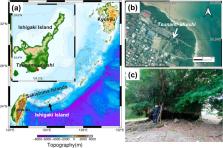
          Huge coastal boulders are useful to reconstruct the size of past extreme waves such as those associated with tsunamis and storms using inverse-type or forward-type boulder transport models. These models fundamentally require the precise shape of boulders. Traditionally, they have often been assumed to be rectangular or ellipsoidal with three axes measured in the field. However, if the boulder’s shape is complex, this method is unable to represent the actual shape accurately. Therefore, it prevents estimation of the tsunami or storm size reasonably using models. For this reason, boulders have recently been surveyed using 3D scanning techniques such as LiDAR. However, coastal boulders now on land in tropical and subtropical areas such as Japan and Tonga are often covered by deep vegetation, which makes 3D surveys difficult. This report presents new methods to ascertain boulder shapes when they are obscured by vegetation. First, using UAV-type and mobile-type LiDAR, we scanned well-known tsunami boulders in southwestern Japan that had been covered with deep vegetation. Then, we developed a new method to extract only boulders and filter out vegetation from a point cloud. Thereby, we created 3D models of the boulders. We improved the boulder transport model further to assume the 3D boulder model accurately. In addition to coastal boulders, this filtering method is expected to be useful for unveiling any object, such as an archaeological structure, that is hidden in deep vegetation.

          Related collections

          Most cited references38

          • Record: found
          • Abstract: not found
          • Article: not found

          Multidimensional binary search trees used for associative searching

            Bookmark
            • Record: found
            • Abstract: not found
            • Article: not found

            Remote sensing platforms and sensors: A survey

              Bookmark
              • Record: found
              • Abstract: not found
              • Article: not found
              Is Open Access

              Ground Filtering Algorithms for Airborne LiDAR Data: A Review of Critical Issues

                Bookmark

                Author and article information

                Contributors
                nakata-koki864@g.ecc.u-tokyo.ac.jp
                Journal
                Sci Rep
                Sci Rep
                Scientific Reports
                Nature Publishing Group UK (London )
                2045-2322
                5 July 2023
                5 July 2023
                2023
                : 13
                : 10918
                Affiliations
                [1 ]GRID grid.26999.3d, ISNI 0000 0001 2151 536X, Department of Earth and Planetary Science, , The University of Tokyo, ; 7-3-1 Hongo, Bunkyo-ku, Tokyo, 113-0033 Japan
                [2 ]GRID grid.440942.f, ISNI 0000 0001 2180 2625, Department of Regional Design, Faculty of Liberal Art, , Tohoku Gakuin University, ; 2-1-1 Tenjinzawa, Izumi-ku, Sendai, Miyagi 981-3193 Japan
                Article
                37985
                10.1038/s41598-023-37985-2
                10322928
                37407602
                0639f8d4-749f-4e94-9d1f-faeb3f9392d5
                © The Author(s) 2023

                Open Access This article is licensed under a Creative Commons Attribution 4.0 International License, which permits use, sharing, adaptation, distribution and reproduction in any medium or format, as long as you give appropriate credit to the original author(s) and the source, provide a link to the Creative Commons licence, and indicate if changes were made. The images or other third party material in this article are included in the article's Creative Commons licence, unless indicated otherwise in a credit line to the material. If material is not included in the article's Creative Commons licence and your intended use is not permitted by statutory regulation or exceeds the permitted use, you will need to obtain permission directly from the copyright holder. To view a copy of this licence, visit http://creativecommons.org/licenses/by/4.0/.

                History
                : 27 January 2023
                : 30 June 2023
                Funding
                Funded by: FundRef http://dx.doi.org/10.13039/501100001691, Japan Society for the Promotion of Science;
                Award ID: 21H04508
                Funded by: Ministry of Education, Culture, Sports, Science and Technology (MEXT) of Japan, under its Second Earthquake and Volcano Hazards Observation and Research Program (Earthquake and Volcano Hazard Reduction Research)
                Categories
                Article
                Custom metadata
                © Springer Nature Limited 2023

                Uncategorized
                natural hazards,ocean sciences
                Uncategorized
                natural hazards, ocean sciences

                Comments

                Comment on this article